- 14 Mar 2002
- 21,050
- 18,903
A powerful typhoon, Shanshan, is forecast to make landfall in western and eastern Japan starting Tuesday. Weather authorities are issuing warnings for severe winds and potential landslides. As of Sunday evening, located south of Japan, the typhoon was moving northwest at 30 kilometres per hour. Shanshan, or Typhoon No.10, has a central atmospheric pressure of 980 hectopascals and is packing maximum sustained winds of 126 kilometres per hour, with gusts reaching 180 kilometres per hour. It is expected to intensify as it continues its northward path by Tuesday before approaching Japan's western and eastern coasts.
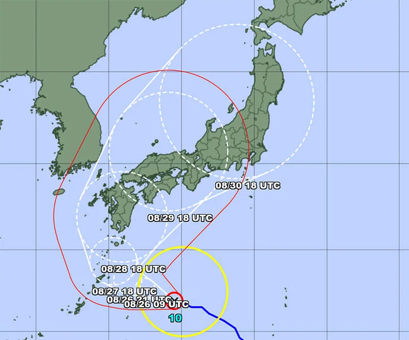
Image credit: JMA

 english.kyodonews.net

 www3.nhk.or.jp
Image credit: JMA
Strong typhoon may hit Japan Aug. 28, shinkansen disruptions expected
A strong typhoon is on course to approach western and eastern Japan on Wednesday or later, the weather agency said, possibly causing widespread disruption to shinkansen bullet train services.
Typhoon Shanshan seen approaching western, eastern parts of Japan from Tuesday | NHK WORLD-JAPAN News
Typhoon Shanshan is expected to approach western and eastern parts of Japan from Tuesday onwards. Weather officials are warning of violent winds and landslides.
www3.nhk.or.jp