


- 14 Mar 2002
- 21,050
- 18,903
The typhoon is expected to affect the Ogasawara islands and eastern and northern Japan, with warnings for heavy rain, landslides, and high waves. Shinkansen services on the Tokaido, Tohoku, Joetsu, Hokuriku, Yamagata, and Akita lines may face closures or suspensions.
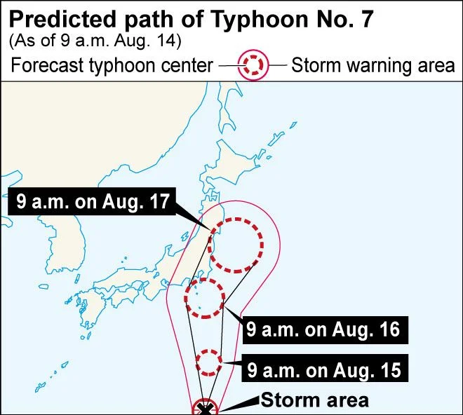
Image credit: Asahi
Friday will be an indoor day.

 www.japantimes.co.jp
Image credit: Asahi
The Japan Meteorological Agency has issued a severe warning for eastern Japan, cautioning residents about landslides, heavy rain, and high waves. As of 9 a.m. on August 14, the typhoon was located west-southwest of Chichijima Island and moving northeast. With a central pressure of 975 hectopascals and maximum winds of 108 kilometers per hour, it is packing a powerful punch. Winds exceeding 90 kilometers per hour are occurring within a 95-kilometer radius of the typhoon's center. In preparation for the typhoon, Central Japan Railway Company (JR Tokai) announced the suspension of Tokaido Shinkansen services between Nagoya and Tokyo on August 16. Other sections of the line may also be closed or suspended on August 16 and 17. To accommodate travelers, JR Tokai will operate an additional bullet train from Shin-Osaka to Tokyo on August 15. All seats on this train are reserved and will be available for purchase on August 14.
Friday will be an indoor day.
On Friday, the current forecast shows the storm strengthening, with expected sustained winds of 144 kph and gusts of up to 216 kph in the Izu Islands and Kanto, and gusts of 126 kph in the Tokai and Tohoku regions. Wave heights could reach 11 meters in Kanto, 10 meters in the Izu Islands, 7 meters in Tohoku and 6 meters in Tokai. Rainfall forecasts predict up to 200 millimetres in the Kanto-Koshin region and 150 mm in the Tokai region in the 24 hours up to 6 a.m. on Friday, with similar amounts expected in the 24 hours up to 6 a.m. Saturday. The storm's exact path remains unclear, with landfall in Chiba Prefecture as one possibility. The storm could also pass by the region over the ocean, but it would still bring the threat of torrential rain and violent winds.
Typhoon to force railway closures as it nears Kanto on Friday
The storm is expected to peak in intensity between Friday and Saturday, prompting the closure of the Tokaido Shinkansen between Tokyo and Nagoya.


