

Navigation
Install the app
How to install the app on iOS
Follow along with the video below to see how to install our site as a web app on your home screen.
Note: This feature may not be available in some browsers.
More options
Style variation
System
Light
Dark
You are using an out of date browser. It may not display this or other websites correctly.
You should upgrade or use an alternative browser.
You should upgrade or use an alternative browser.
North, West, What-the-heck?!
- Thread starter Ukigumo
- Start date
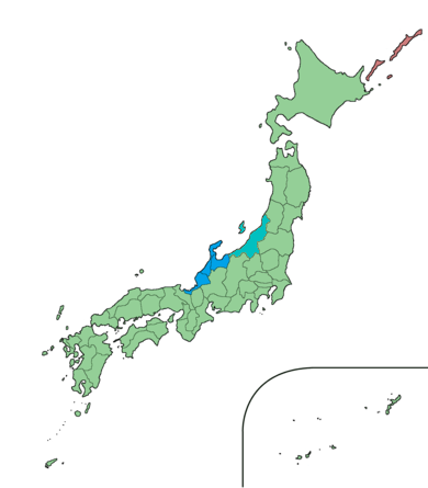
Hokuriku region - Wikipedia

Ukigumo
後輩
- 15 Mar 2025
- 1,382
- 2,684
- Thread starter
- #4
So the archipelago has been 'mentally twisted' into a north-south orientation?My understanding:
I'm unsure about Hokuriku and Tokai. I don't think there's a formal nomenclature.
- North: Hokkaido, Tohoku (actually "northeast")
- East: Kanto, eastern Chubu
- West: Kansai/Kinki, Chugoku, Shikoku
- South: Kyushu, Okinawa


- 14 Mar 2002
- 21,050
- 18,903
So the archipelago has been 'mentally twisted' into a north-south orientation?
Sort of. A bit like Greenland being depicted on maps as the size of Africa, when it's actually smaller than Algeria.

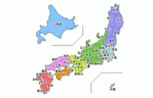
Travel Regions of Japan
Japan consists of eight regions. While these regions do not constitute administrative or political units, they play a traditional role in history, education, economy and also in the media. The major power supply companies (such as Tohoku Electric Power Co., Tokyo Electric Power Co., Kansai...
Ukigumo
後輩
- 15 Mar 2025
- 1,382
- 2,684
- Thread starter
- #6
Yes, I saw a video about the 'Mercator projection' of Greenland the other day and although I had an idea of it's distortion, I didn't realise just how profound it is!Sort of. A bit like Greenland being depicted on maps as the size of Africa, when it's actually smaller than Algeria.
Travel Regions of Japan
Japan consists of eight regions. While these regions do not constitute administrative or political units, they play a traditional role in history, education, economy and also in the media. The major power supply companies (such as Tohoku Electric Power Co., Tokyo Electric Power Co., Kansai...

- 18 Jan 2005
- 11,682
- 3,638
How the Japanese Archipelago Was Formed
The Japanese archipelago was not originally a group of islands. It was formed over hundreds of millions of years through plate tectonics, volcanic activity, and changes in sea level.
1. Part of the Asian Continent
Several hundred million years ago, what is now Japan was part of the eastern edge of the Eurasian continent. Sediments and volcanic materials accumulated along the continental margin, gradually forming complex geological layers.
2. Subduction and Volcanic Activity
Oceanic plates such as the Pacific Plate and the Philippine Sea Plate began to subduct beneath the continent.
Subduction caused magma to form underground
This led to frequent volcanic eruptions and earthquakes
Japan became part of the Pacific "Ring of Fire"
3. Formation of the Sea of Japan
Around 20 million years ago, the continental edge was stretched and pulled apart.
The landmass split from the continent
Seawater flowed in, forming the Sea of Japan
The Japanese islands rotated and drifted eastward
4. Fossa Magna and East–West Differences
During this process, a large tectonic zone called the Fossa Magna formed in central Japan.
Eastern Japan has younger geological formations
Western Japan has older rock layers
This explains differences in terrain, earthquakes, and volcanoes between east and west Japan
5. Ice Ages and the Present Shape
During the Ice Ages, sea levels dropped, connecting Japan to the continent by land bridges. Animals and humans migrated during these periods. When sea levels rose again, Japan became isolated islands.
Summary
Japan was formed by:
Continental margin growth
Plate subduction
Volcanic activity
Tectonic separation from Asia
This active geological history explains why Japan has many mountains, earthquakes, volcanoes, and hot springs today.
The Japanese archipelago was not originally a group of islands. It was formed over hundreds of millions of years through plate tectonics, volcanic activity, and changes in sea level.
1. Part of the Asian Continent
Several hundred million years ago, what is now Japan was part of the eastern edge of the Eurasian continent. Sediments and volcanic materials accumulated along the continental margin, gradually forming complex geological layers.
2. Subduction and Volcanic Activity
Oceanic plates such as the Pacific Plate and the Philippine Sea Plate began to subduct beneath the continent.
Subduction caused magma to form underground
This led to frequent volcanic eruptions and earthquakes
Japan became part of the Pacific "Ring of Fire"
3. Formation of the Sea of Japan
Around 20 million years ago, the continental edge was stretched and pulled apart.
The landmass split from the continent
Seawater flowed in, forming the Sea of Japan
The Japanese islands rotated and drifted eastward
4. Fossa Magna and East–West Differences
During this process, a large tectonic zone called the Fossa Magna formed in central Japan.
Eastern Japan has younger geological formations
Western Japan has older rock layers
This explains differences in terrain, earthquakes, and volcanoes between east and west Japan
5. Ice Ages and the Present Shape
During the Ice Ages, sea levels dropped, connecting Japan to the continent by land bridges. Animals and humans migrated during these periods. When sea levels rose again, Japan became isolated islands.
Summary
Japan was formed by:
Continental margin growth
Plate subduction
Volcanic activity
Tectonic separation from Asia
This active geological history explains why Japan has many mountains, earthquakes, volcanoes, and hot springs today.


- 18 Jan 2005
- 11,682
- 3,638
Why Japan Is Classified into Northern, Eastern, and Western Regions
Japan is commonly divided into Northern Japan, Eastern Japan, and Western Japan, not because of a strict geographic line, but due to climate, geography, history, and practical administrative needs.
The most important factor is climate.
Northern Japan, including Hokkaido and Tohoku, has long, cold winters with heavy snowfall.
Western Japan, such as Kansai, Chugoku, Shikoku, and Kyushu, has milder winters and hot, humid summers.
Eastern Japan lies between these two and shows mixed climatic characteristics.
Geography also plays a major role. Japan's many mountain ranges, including the Japanese Alps, block air flows and create sharp regional weather differences, reinforcing these divisions.
Over time, these natural differences led to distinct cultural and historical patterns, such as variations in dialects, food flavors, and customs, which further strengthened regional classifications.
Finally, the divisions are used for administrative and statistical convenience, especially in weather forecasts, disaster information, and government data.
As a result, the boundaries are not fixed, and some regions fall into different categories depending on the context.
First, geography plays a key role.
Sekigahara lies in a narrow mountain pass connecting the Kanto–Chubu region with the Kansai region. This pass has long acted as a natural gateway where climate patterns, transportation routes, and human movement change.
Second, climate differences become noticeable around Sekigahara.
The influence of winter monsoon winds and snowfall patterns shifts in this region, marking a transition between eastern and western climate characteristics.
Third, linguistic and cultural boundaries converge here.
Japanese dialects and pitch accents change around the Sekigahara area, with western-style accents and customs becoming dominant to the west, and eastern patterns to the east.
Fourth, infrastructure differences reinforce the divide.
Japan's electrical frequency changes from 50 Hz in the east to 60 Hz in the west, with the boundary located near Sekigahara. This technical division reflects historical differences in industrial development.
Finally, history strengthened the symbolic importance of Sekigahara.
The Battle of Sekigahara in 1600 established a political division between eastern and western forces, fixing the area's image as Japan's east–west boundary in the national consciousness.
Japan is commonly divided into Northern Japan, Eastern Japan, and Western Japan, not because of a strict geographic line, but due to climate, geography, history, and practical administrative needs.
The most important factor is climate.
Northern Japan, including Hokkaido and Tohoku, has long, cold winters with heavy snowfall.
Western Japan, such as Kansai, Chugoku, Shikoku, and Kyushu, has milder winters and hot, humid summers.
Eastern Japan lies between these two and shows mixed climatic characteristics.
Geography also plays a major role. Japan's many mountain ranges, including the Japanese Alps, block air flows and create sharp regional weather differences, reinforcing these divisions.
Over time, these natural differences led to distinct cultural and historical patterns, such as variations in dialects, food flavors, and customs, which further strengthened regional classifications.
Finally, the divisions are used for administrative and statistical convenience, especially in weather forecasts, disaster information, and government data.
As a result, the boundaries are not fixed, and some regions fall into different categories depending on the context.
Why Sekigahara Is Considered the East–West Divide of Japan
Sekigahara is often regarded as the dividing line between Eastern Japan and Western Japan because multiple natural, cultural, and historical boundaries overlap in this area.First, geography plays a key role.
Sekigahara lies in a narrow mountain pass connecting the Kanto–Chubu region with the Kansai region. This pass has long acted as a natural gateway where climate patterns, transportation routes, and human movement change.
Second, climate differences become noticeable around Sekigahara.
The influence of winter monsoon winds and snowfall patterns shifts in this region, marking a transition between eastern and western climate characteristics.
Third, linguistic and cultural boundaries converge here.
Japanese dialects and pitch accents change around the Sekigahara area, with western-style accents and customs becoming dominant to the west, and eastern patterns to the east.
Fourth, infrastructure differences reinforce the divide.
Japan's electrical frequency changes from 50 Hz in the east to 60 Hz in the west, with the boundary located near Sekigahara. This technical division reflects historical differences in industrial development.
Finally, history strengthened the symbolic importance of Sekigahara.
The Battle of Sekigahara in 1600 established a political division between eastern and western forces, fixing the area's image as Japan's east–west boundary in the national consciousness.
Summary
Sekigahara is considered Japan's east–west divide because geography, climate, language, infrastructure, and history all intersect there, making it a natural and symbolic boundary rather than a strictly defined border.
- 18 Jan 2005
- 11,682
- 3,638
Fossa Magna (Summary)
The Fossa Magna is a major geological zone that divides eastern and western Japan.
It stretches from Itoigawa in Niigata Prefecture to Shizuoka in central Honshu.
It was formed about 20 million years ago when the Japanese islands separated from the Asian continent and the Sea of Japan opened, causing the crust to sink and fracture.
The western edge of the Fossa Magna is marked by the Itoigawa–Shizuoka Tectonic Line, which represents a major geological boundary.
This zone is closely related to the formation of the Japanese Alps, where intense crustal movement created high mountain ranges.
Formation and Naming of the Japanese Alps
The Japanese Alps consist of the Northern Alps (Hida Mountains) and the Southern Alps (Akaishi Mountains).
They were formed by tectonic plate collisions that caused intense crustal compression and rapid uplift.
The Northern Alps began forming about 5 million years ago and are characterized by sharp granite peaks and dramatic alpine scenery.
The Southern Alps, forming mainly over the last 10 million years, are broader and higher in overall mass, and they are still rising today.
The name "Japanese Alps" was given by Walter Weston, a British missionary and mountaineer, in the late 19th century.
After exploring the mountains, he noted their similarity in beauty and steepness to the European Alps and introduced the term to the world.
Although they share the name, the Japanese Alps are geologically younger and more actively uplifting than the European Alps.
The Median Tectonic Line (MTL)
The Median Tectonic Line (MTL) is the largest and longest fault zone in Japan, stretching over 1,000 km from Kyushu through Shikoku and the Kii Peninsula to central Honshu.
It began forming about 100 million years ago during intense tectonic activity along the edge of the Asian continent.
The MTL is mainly a strike-slip fault and separates geologically distinct regions.
Across the fault, the Ryoke Belt (granite and metamorphic rocks) lies to the north, while the Sanbagawa Belt (high-pressure metamorphic rocks) lies to the south.
Although it is sometimes confused with the Fossa Magna, the Median Tectonic Line is a different structure and mainly affects western Japan.
Parts of the MTL are still active and are important for understanding earthquakes in Japan.
The Fossa Magna is a major geological zone that divides eastern and western Japan.
It stretches from Itoigawa in Niigata Prefecture to Shizuoka in central Honshu.
It was formed about 20 million years ago when the Japanese islands separated from the Asian continent and the Sea of Japan opened, causing the crust to sink and fracture.
The western edge of the Fossa Magna is marked by the Itoigawa–Shizuoka Tectonic Line, which represents a major geological boundary.
This zone is closely related to the formation of the Japanese Alps, where intense crustal movement created high mountain ranges.
Formation and Naming of the Japanese Alps
The Japanese Alps consist of the Northern Alps (Hida Mountains) and the Southern Alps (Akaishi Mountains).
They were formed by tectonic plate collisions that caused intense crustal compression and rapid uplift.
The Northern Alps began forming about 5 million years ago and are characterized by sharp granite peaks and dramatic alpine scenery.
The Southern Alps, forming mainly over the last 10 million years, are broader and higher in overall mass, and they are still rising today.
The name "Japanese Alps" was given by Walter Weston, a British missionary and mountaineer, in the late 19th century.
After exploring the mountains, he noted their similarity in beauty and steepness to the European Alps and introduced the term to the world.
Although they share the name, the Japanese Alps are geologically younger and more actively uplifting than the European Alps.
The Median Tectonic Line (MTL)
The Median Tectonic Line (MTL) is the largest and longest fault zone in Japan, stretching over 1,000 km from Kyushu through Shikoku and the Kii Peninsula to central Honshu.
It began forming about 100 million years ago during intense tectonic activity along the edge of the Asian continent.
The MTL is mainly a strike-slip fault and separates geologically distinct regions.
Across the fault, the Ryoke Belt (granite and metamorphic rocks) lies to the north, while the Sanbagawa Belt (high-pressure metamorphic rocks) lies to the south.
Although it is sometimes confused with the Fossa Magna, the Median Tectonic Line is a different structure and mainly affects western Japan.
Parts of the MTL are still active and are important for understanding earthquakes in Japan.
- 18 Jan 2005
- 11,682
- 3,638
"Zero Magnetic Field" Areas in Japan
In Japan, the term "zero magnetic field" is a popular expression referring to places where the Earth's magnetic field becomes unusually weak due to geological conditions.
It does not mean that the magnetic field is completely zero.
The most well-known example is Bungui Pass (Bungui-toge) in Nagano Prefecture , which lies directly on the Median Tectonic Line (MTL), Japan's largest fault zone.
Along the MTL, rocks with different magnetic properties and orientations meet, causing their magnetic effects to partially cancel each other out.
As a result, the local geomagnetic field becomes unstable or weakened, and compasses may behave erratically.
Scientifically, these areas are classified as geomagnetic anomalies.
Although they are often described as "energy spots" in popular culture, such claims are not supported by scientific evidence.
In Japan, the term "zero magnetic field" is a popular expression referring to places where the Earth's magnetic field becomes unusually weak due to geological conditions.
It does not mean that the magnetic field is completely zero.
The most well-known example is Bungui Pass (Bungui-toge) in Nagano Prefecture , which lies directly on the Median Tectonic Line (MTL), Japan's largest fault zone.
Along the MTL, rocks with different magnetic properties and orientations meet, causing their magnetic effects to partially cancel each other out.
As a result, the local geomagnetic field becomes unstable or weakened, and compasses may behave erratically.
Scientifically, these areas are classified as geomagnetic anomalies.
Although they are often described as "energy spots" in popular culture, such claims are not supported by scientific evidence.

Similar threads


- Replies
- 421
- Views
- 142K
