

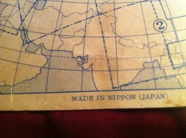
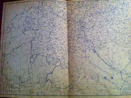
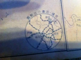
Hello to all who reads this. I have a pretty old map, probably made in the early 1900's judging by the "Made in Nippon" on the bottom of the first page. This map folds out so that its panorama style and has several different pages. It's also double sided. One side is in color and the other is in black and white. Please see pics attached.
Navigation
Install the app
How to install the app on iOS
Follow along with the video below to see how to install our site as a web app on your home screen.
Note: This feature may not be available in some browsers.
More options
Style variation
System
Light
Dark

You are using an out of date browser. It may not display this or other websites correctly.
You should upgrade or use an alternative browser.
You should upgrade or use an alternative browser.
Please help me
- Thread starter japxican
- Start date


Glenn
一切皆苦
- 8 Jan 2004
- 7,842
- 200
They're based in Nagoya and publish a monthly publication that comes out on the 7th of every month that deals mainly with business, it seems (550 yen).
I was working under the assumption that it's an itaiji of 局, or maybe that there's just an error in printing or something.
It's a new year's edition, too
Glenn, what on Earth is the second kanji after 時 in 時?重要地圖 it is not 局, right? It seems like 口 + 弓, to me.
I don't have any dictionary here so I cannot check it >.<
I was working under the assumption that it's an itaiji of 局, or maybe that there's just an error in printing or something.
Last edited:
Glenn
一切皆苦
- 8 Jan 2004
- 7,842
- 200
Yes, it is an itaiji. See if you can see this: http://dict.variants.moe.edu.tw/yitia/fra/fra01079.htm (you're probably going to have to set the encoding to Traditional Chinese Big 5).
They didn't have any English that I saw. I was just translating off of the "about" page.
They didn't have any English that I saw. I was just translating off of the "about" page.
- Thread starter
- #9
Thank you, Glen & Ryuurui.
What's with the 10-1 on the cover? Sorry for the all ?'s but I've spent a lot of time doing my own internet research. I was able to locate some books that I have on the web, just by looking at the pics and using google translator. Thought I'd be able to locate the map, too.
What's with the 10-1 on the cover? Sorry for the all ?'s but I've spent a lot of time doing my own internet research. I was able to locate some books that I have on the web, just by looking at the pics and using google translator. Thought I'd be able to locate the map, too.
Thank you, Glen & Ryuurui.
What's with the 10-1 on the cover? Sorry for the all ?'s but I've spent a lot of time doing my own internet research. I was able to locate some books that I have on the web, just by looking at the pics and using google translator. Thought I'd be able to locate the map, too.
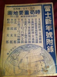
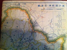
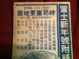
it's a reference to 10 maps included, for 10 regions of financial traffic.
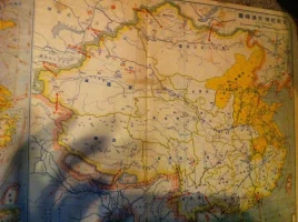
Your map4 (pic 4) is no.3 on the legend, etc.
Glenn
一切皆苦
- 8 Jan 2004
- 7,842
- 200
Here's basically what you're dealing with:
(On the right) Supplement to Fuji New Year Edition
(At the top) Convenient and easy to read practical maps
Situational Important Maps (not sure about this, but jikyoku may mean "situation" or something like that, and not refer to the company)
Edited/compiled by the Imperial Map Institute (just guessing at an official English name for that)
1. General economic/traffic map of China
2. Economic/traffic map of important Chinese regions
3. Economic/traffic map of Manchuria
4. Detailed map of the Soviet/Manchurian border
5. Latest map of Soviet Union (complete)
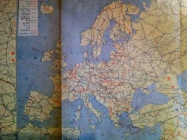
6. Complete map of Europe
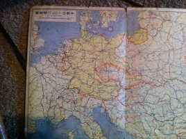
7. Detailed map of Central Europe
8. Northern China
9. Central China
10. Southern China
I haven't seen a year of issue. Although, it looks like The Jikyoku Company's first publication was 1968, and that doesn't quite line up with the printing on the maps. It seems like it'd be around the 1920s. It's after the Soviet Union formed (around 1917, right?) and before the Japanese Empire was defeated (1945). So, 20s or 30s is a safe guess, I'd say.
(On the right) Supplement to Fuji New Year Edition
(At the top) Convenient and easy to read practical maps
Situational Important Maps (not sure about this, but jikyoku may mean "situation" or something like that, and not refer to the company)
Edited/compiled by the Imperial Map Institute (just guessing at an official English name for that)
1. General economic/traffic map of China
2. Economic/traffic map of important Chinese regions
3. Economic/traffic map of Manchuria
4. Detailed map of the Soviet/Manchurian border
5. Latest map of Soviet Union (complete)
6. Complete map of Europe
7. Detailed map of Central Europe
8. Northern China
9. Central China
10. Southern China
Do you know what year it was issued?
I haven't seen a year of issue. Although, it looks like The Jikyoku Company's first publication was 1968, and that doesn't quite line up with the printing on the maps. It seems like it'd be around the 1920s. It's after the Soviet Union formed (around 1917, right?) and before the Japanese Empire was defeated (1945). So, 20s or 30s is a safe guess, I'd say.
Last edited:
- Thread starter
- #13
Thank you, Glen for the information. It's frustrating to have beautiful publication but unable to read it. I'll upload some pics of the books that I was able to find online...full of history. VERY frustrating that I won't be able to enjoy reading.
Last edited:
So this is an interesting map... its not exactly clear when it might be based on the images provided. Map #2 posted shows a very odd borders for South Asia. There is India and Afghanistan, but Pakistan is about 1/3 its normal size that corresponds to Baluchistan. However that was part of Colonial India at the time so it should not be represented in such a fashion. Indochina exists in this photo (which existed until 1955), but Mongolia does not (fully recognized in 1945, but existed in 1921). The middle east area corresponds to Colonial administered era (1923~1946), but that just might be due to map size.
If you can scan maps 1 (China), 4 (Korea) and 7(Europe), I can give you a better sense of the date.
If you can scan maps 1 (China), 4 (Korea) and 7(Europe), I can give you a better sense of the date.

- 22 Feb 2008
- 18,266
- 4,926
I found the same map listed in an auction site. Apparently, it was published in 昭和14年, i.e., 1939.
I agree. 時局 is not the name of the publishing company but means "the current situation" here.Glenn;690185 said:Situational Important Maps (not sure about this, but jikyoku may mean "situation" or something like that, and not refer to the company)
Glenn
一切皆苦
- 8 Jan 2004
- 7,842
- 200
At 550 yen there's no way it was early 1900s. You could have built an exquisitely fine home back then for less than that.
That's the current price of the publication, according to the 時局社 site.

undrentide
Japa'n vagyok
- 18 Jan 2006
- 3,652
- 310
it's a new year's edition, too
Glenn, what on Earth is the second kanji after 時 in 時?重要地圖 it is not 局, right? It seems like 口 + 弓, to me.
I dont have any dictionary here so I cannot check it >.<
Glenn;690178 said:I was working under the assumption that it's an itaiji of 局, or maybe that there's just an error in printing or something.
時局重要地圖 = 時局重要地図.
圖 is 異体字 (itaiji) for 図.
As for 局 and 要, I guess they are just design, I checked itaiji for them, either 跼 or 侷 for 局 and could not find any for 要.
You can check out itaiji here:
世界漢字字典

- 15 Mar 2002
- 16,758
- 2,298
That's the current price of the publication, according to the 時局社 site.
I just looked at the cover scan for the first time (iPhone, so I hadn't bothered before). The old kanji make it obvious at a glance it is a pre-1945 publication. The font is also typical of that period, I think. I rather like that style. Notice also the use of 支那 instead of 中国.
I believe the price, date, and publisher are probably in the blurry small print at the very tiptop of the cover. If the OP could redo the image and get that area in focus it would probably clear up a lot of questions.
- 22 Feb 2008
- 18,266
- 4,926
The magazine 富士 was published by 講談社; Kodansha Limited.
The price of the first issue was 50 sen(0.5 yen).
キング (雑誌) - Wikipediaしかし1943年(昭和18年)には、「キング」が敵性語であるという理由で『富士』に改題された(改題からしばらくの間は、「キング 改題 富士」と表記されていた)。
The price of the first issue was 50 sen(0.5 yen).
Glenn
一切皆苦
- 8 Jan 2004
- 7,842
- 200
時局重要地圖 = 時局重要地図.
圖 is 異体字 (itaiji) for 図.
As for 局 and 要, I guess they are just design, I checked itaiji for them, either 跼 or 侷 for 局 and could not find any for 要.
You can check out itaiji here:
世界漢字字典
I was a bit surprised at first, because I thought I was looking at 耍 (which means something like "mess around"), but that's got 而 and 女, and it's got nothing to do with 要. At least according to the Taiwanese MOE's variant dictionary, what's on the map is an 異体字 of 要. Again, you'll probably have to change the encoding to Traditional Chinese Big 5.
I was not aware of the gigadict variant dictionary.
The old kanji make it obvious at a glance it is a pre-1945 publication. The font is also typical of that period, I think. I rather like that style.
I like it too, and wish it had stayed.
Mike Cash said:Notice also the use of 支那 instead of 中国.
Yeah, I guess before it became a derogatory term, apparently because Chiang Kai-shek said it was discriminatory. At least that's what a precursory look at the term on Wikipedia says.
The magazine 富士 was published by 講談社; Kodansha Limited.
キング (雑誌) - Wikipedia
The price of the first issue was 50 sen(0.5 yen).
Oooooh, good find.
Also notice that 富士 on the map is written 冨士 (ワ冠 on the map as opposed to ウ冠).
Last edited:
- 22 Feb 2008
- 18,266
- 4,926
Delete "http://" from the URLs, then you can post it.;-)
BTW, this is a complete contradiction. :emoji_blush:
it was published in 昭和14年, i.e., 1939.
しかし1943年(昭和18年)には、「キング」が敵性語で あるという理由で『富士』に改題された
Apparently, there was another magazine Fuji that was not the renamed version of King.
誰か昭和を想わざる 「キング」の時代
湧書館古書目録
BTW, this is a complete contradiction. :emoji_blush:
it was published in 昭和14年, i.e., 1939.
しかし1943年(昭和18年)には、「キング」が敵性語で あるという理由で『富士』に改題された
Apparently, there was another magazine Fuji that was not the renamed version of King.
若者向けの「雄弁」と「富士」のうち...
... 「富士」は時事的な話題を特に取り上げた雑誌だったようである。昭和4年の新年号では
誰か昭和を想わざる 「キング」の時代
芝居と映画 名流花形大寫眞帖 富士新年号附録 昭和6年1月・第4巻第1号附録
湧書館古書目録
Similar threads


- Replies
- 20
- Views
- 14K

- Replies
- 28
- Views
- 8K

