What's new

Walking to Kyoto

ginlane

後輩
27 Mar 2016
80
5
18
Hi there,
I live with my friend in a house in West Kyoto , right on the edge of town in the hills.
She told me recently that the trial (which runs past our house) if I follow it will eventually take me to Kyoto.
But, she said I had to be careful as there are many different ways to get there.
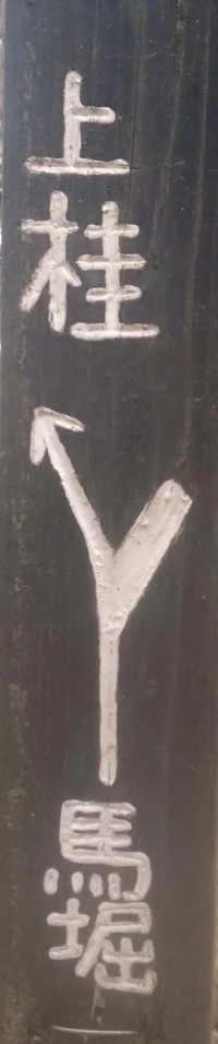
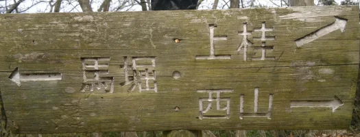
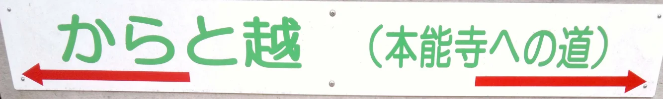
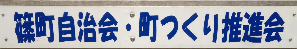
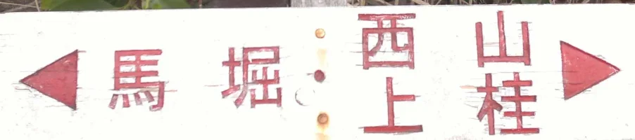
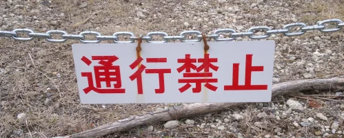
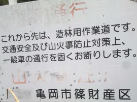
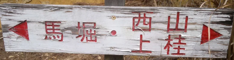
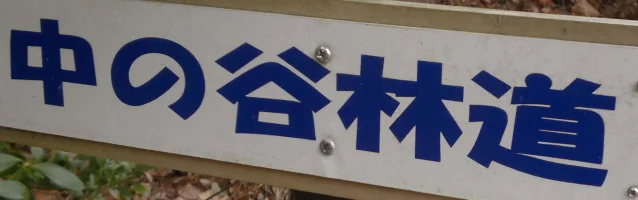
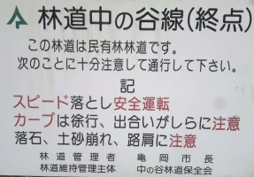
So the other day I started walking along there, after about half an hour I came across a bunch of signs pointing in different directions all in Japanese.
Please could someone tell me what they are saying and where they are telling me to go.
As I said, Kyoto is my preferred destination
kind regards Prem :)
 

Attachments

  • Wood Walk (1).jpg
    Wood Walk (1).jpg
    554.6 KB · Views: 115
  • Wood Walk (2).jpg
    Wood Walk (2).jpg
    111.7 KB · Views: 136
  • Wood Walk (3).jpg
    Wood Walk (3).jpg
    137 KB · Views: 116
  • Wood Walk (4).jpg
    Wood Walk (4).jpg
    46.1 KB · Views: 154
  • Wood Walk (5).jpg
    Wood Walk (5).jpg
    564.6 KB · Views: 128
  • Wood Walk (6).jpg
    Wood Walk (6).jpg
    373.5 KB · Views: 125
  • Wood Walk (7).jpg
    Wood Walk (7).jpg
    389 KB · Views: 130
  • Wood Walk (8).jpg
    Wood Walk (8).jpg
    75.7 KB · Views: 132
  • Wood Walk (9).jpg
    Wood Walk (9).jpg
    98 KB · Views: 122
  • Wood Walk (10).jpg
    Wood Walk (10).jpg
    429.3 KB · Views: 114
You have enough trouble in grocery stores; stay off the mountain trails. Seriously, if you can't find a map for them and follow yourself through with GPS on your phone then you have no business risking getting lost in the woods. There are apps and maps available if you have an iPhone. (search for Yamap, but you will need help downloading tbe needed maps).
 
Case in point: some of the signs you photographed were not direction signs, but "entry prohibited" or "maintenance road". The one with big red characters hanging on a chain was one of those :)

Map apps for walking are aplenty, not just for iPhone but for Android too. Then again - I say "walking", but the signs indicate there are cars passing there too.
 
You have enough trouble in grocery stores; stay off the mountain trails. Seriously, if you can't find a map for them and follow yourself through with GPS on your phone then you have no business risking getting lost in the woods. There are apps and maps available if you have an iPhone. (search for Yamap, but you will need help downloading tbe needed maps).

:) yeah tell me about it, I'm getting thin out here, buying stuff that looks nice in the store only to get home find it some weird inedible gloop. unfortunately I don't have a smart phone, (trying to live life without one) I'll check out and see if I can download Yamap onto my laptop
 
Case in point: some of the signs you photographed were not direction signs, but "entry prohibited" or "maintenance road". The one with big red characters hanging on a chain was one of those :)

Map apps for walking are aplenty, not just for iPhone but for Android too. Then again - I say "walking", but the signs indicate there are cars passing there too.

Lanthas, was the sign with the chain to say was a maintenance road or to indicate entry prohibited?
 
:) yeah tell me about it, I'm getting thin out here, buying stuff that looks nice in the store only to get home find it some weird inedible gloop. unfortunately I don't have a smart phone, (trying to live life without one) I'll check out and see if I can download Yamap onto my laptop

Do you know the name of the trail? Maybe we can help you find a map you can print out.
 
I don't unfortunately, but this is Google maps, the Trail runs off to the top right corner

Google マップ

Unfortunately, it doesn't seem to be listed among the trails in Kameoka City.

https://www.city.kameoka.kyoto.jp/kokusaikouryuu/kanko/outdoors/hiking.html

Here is a detailed topographical map of the area, with trails indicated.

場所情報コードを表示

I think the dashed lines are trails, but I wouldn't swear to it. You may have to play with the zoom level to see them.

I would encourage you to go going on one of the trails on the city website instead, and if possible to take someone with you.

Do you have any cell phone at all with you? If you get lost and need to be rescued, call 110 (police emergency number).
 
unfortunately I don't have a smart phone,
Wow you really are roughing it. :)
Lanthas, was the sign with the chain to say was a maintenance road or to indicate entry prohibited?
The chain one was entry-prohibited.

I highly recommend you go to your local bookstore and grab a Y1000 topo map of the area.
Probably this is the one you need: http://www.amazon.co.jp/山と高原地図-北摂・京都西山-2016-登山地図-マップル/dp/4398763074/
It will make your hikes in the area much much better. Mark the places you go and it will be a great souvenir eventually.

It looks to me like 馬堀 will lead you to Umahori station in Kameoka.
And 上桂 will lead you to Kamikatsura station in Kyoto.
Maybe 西山 (Nishiyama) goes here.

Does it look like this page covers the trail in question?
京都一周トレール(4)、唐櫃越
 
Last edited:
You are 43 and having this much trouble? I'm finding it hard to believe. Even harder is that you don't seem to be getting help from a presumed girlfriend who is rarely around or who refuses to help, yet she allows you to live in her home. Forgive me for being skeptical at this point.
 
You are 43 and having this much trouble? I'm finding it hard to believe. Even harder is that you don't seem to be getting help from a presumed girlfriend who is rarely around or who refuses to help, yet she allows you to live in her home. Forgive me for being skeptical at this point.

He has never claimed it is his girlfriend. I get the impression the friend may be a fellow foreigner and perhaps equally clueless and not really able to help him. Nobody could have this much trouble with such easy stuff if living with an even marginally competent adult native, especially one with a romantic interest working as well.
 
Back
Top Bottom