Satellite Imagry Shows ancient Human Habitation on ocean floors

Northern Hiroshima, river bank and forest preserve area

I am visiting Hiroshima today, on the river-front, Northern area of the City, with the Eastern side showing some form of preserve or park.

Virtually every 50 feet of these green areas shows some ancient astronomical alignment, geoglyphs, or altar structures. I have attempted to square off what appears to be a temple complex overgrown by vegetation, to the East and slight North.

Given my limited understanding of what these astronomical markings mean, or when they were constructed, I have to make the observation that they match the ocean floor Venus arrangements and stone circle similarities, with an age deep into antiquity. (I am guessing at 2000 BC or previous)

The bottom line is that every piece of green space, whether in the river channel or in the forest preserve, shows heavy altar or shrine locations, with many ancient human habitat indicators.

First view, large scale, positioning Hirohshima on the southern side of Japan.
111hiro555ry2thgif-1.webp

Second view, northern portion of Hiroshima, with blue arrows added where I found riverbank altars, shrines, and astronomical alignment points. A University will find much of antiquities and history in this area, I believe.

http://img410.imageshack.us/my.php?image=222hiroarrows555lw1.gif

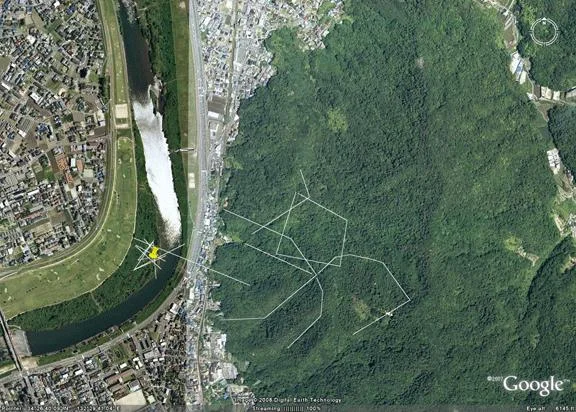
Third view, riverbend area and Eastern forest Preserve area, showing major concentrations of stellar convergence points, altars, and habitat areas. There are so many temple, altar, and geoglyph indicators under the vegetation, I have limited my markings for an easier view.
333hiro50feet555zg5gif-1.webp
http://g.imageshack.us/g.php?h=45&i=333hiro50feet555zg5.gif

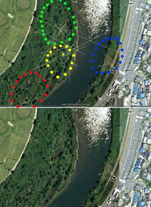
Fourth view, explicit riverbend area, with stellar alignments and stone circle indicators, matching previous ツ"megalithic, Stonehenge-eraツ" stellar alignment points, and apparent Venus grid.
444hiroclose666ty5gif-1.webp
http://g.imageshack.us/g.php?h=59&i=444hiroclose666ty5.gif

Every naturally green area I look at, in Japan, is similarly marked.

Google Earth map of locationツ…
Google Maps
 
Face Cliffs... Ancient land/sea navigation aids...

I am thrilled to be able to find two probable navigational sculptures on the coasts of Japan:

The first is a 10-mile long ツ"face cliffツ" on an island off the coast of Japan, which seems to have survived the ravages of time.

facecliffjapan1555mu4gif-1.webp
http://g.imageshack.us/g.php?h=236&i=facecliffjapan1555mu4.gif

Google Map
Google Maps

The second seems to have not quite survived the trials of the millennia, and may just be my imagination. However, the facial features seem to be striking and lifelikeツ… and I will let future historians pass judgement on this one.

There are several other ツ"maybesツ" that I found up and down the mainland that are too vague to present, but probably ARE face cliffs from the ancient Japanese past.

face2555nu2gif-1.webp
http://g.imageshack.us/g.php?h=135&i=face2555nu2.gif

Google Map
Google Maps

The third exampleツ… I say yes it is, but I cannot be sure.
Google Maps

These ツ"face-cliffツ" sculptures, sometimes 100 miles in length, were used for navigation aids for sailing ships who needed to instantly identify what coastline they were approaching. A wrong approach could mean falling into unfriendly hands, so this identification was life and death critical.

Only my amateur observation and opinion, but in pre-flood times, when the lands around the present coastline of Japan were more dry and actual roads led from one location to another in what are now ocean floor areas, these navigation aids would also be used to identify friendly ツ"land-ports of callツ".

I have found many of these face cliffs in the area of Gibraltar, Morocco, and the Straits of Yucatan, but this is my first on the Pacific Asian side and I am thrilled!

Note: If I can find two face cliffs, then there are probably 100 more yet to be found.
 
Yanai East, Underwater geoglyphs and habitats

This next group of underwater habitat images I am calling ツ"Yanai Eastツ".

The first image is of the island areas East of Yanai, showing aquamarine shallow water around the islands, and then an area to the southwest apparently obscured.

areafigs222vu9thgif-1.webp

Google Map
Google Maps

The entire aquamarine area is a wall-to-wall tapestry of images, and some rich person or academic institution could make an immediate mark on history by doing wide-area radar/sonar images of these inter-island floors. These new technologies display all images down to bedrock, and his/her/their efforts will be instant historic recognition.

Using the wonderful but simplistic tools of Google Earth and Photoshop, I still come up with a saturation of faint geoglyph images which must be 4000 years old or earlier (possibly ice age), and some of the images seem to match the geometric patterns displayed by Lexico in his 2005 thread Underwater Pyramids of Iseki Pointツ… The Underwater Pyramid of Iseki Point?

Agricultural terraces, convergence points, roads, faint geoglyphs
agriterraces222333lo9th-1.webp

Intricate geoglyph Designs
figs222333444555ve5thgif-1.webp

Rising Valley floor to Higher Ground, Sloping Geoglyphs?
mother4222vz5-1.webp
http://g.imageshack.us/g.php?h=244&i=mother4222vz5.jpg

Another rising wall geoglyph areaツ…
motherangel75222333sx6th-1.webp
 
Progressive Face Cliffs, West Coast of Japan/Gibraltar

First of all, I found two more face cliffs on the West Coast of Japan, and that is very interesting to me in that it matches the navigation aids found in the Yucatan Channel, the East Coast of the Americas, and the Spanish and North-African Coastlines near Gibraltar.

Full Japan locator, Peninsula face cliffs...
http://img511.imageshack.us/my.php?image=1fulljapanfa66hr0.gif

Face #1
2facstjapanw6yb9gif-1.webp
http://g.imageshack.us/g.php?h=55&i=2facstjapanw6yb9.gif
Google Map
Google Maps

Face #2
http://imageshack.us
http://g.imageshack.us/g.php?h=182&i=3fa2compare6he0.gif

But that is not the full story, in that the two that I found, approximately 10 miles in height, ALSO show what appears to be two preceding face cliffs further West on the underwater shelf off Western Japan.

Comparison, Images 1 and 2 with image 3, 25 miles West of the present coastline of Japan...

4wjapanshlf66sw3thgif-1.webp

Comparison: Image 3 with Image 4, West of Images 1 and 2

5wjapan4f777zv1thgif-1.webp

Here is the story I am proposing...

As we know, face cliffs seemed to have been designed in antiquity for either land navigation aids and/or sailing navigation aids. Typically off America, they are in the scale of 95 miles high or so, if they were measured vertically.
The question becomes, if the eyes can see 25 miles into the distance, directly in front, what is the lateral vision distance? I am leaning towards a maximum of 100 miles laterally (left to right), if one is looking up from a Valley floor at mountain peaks of 5000 feet or so in the distance. Experts can correct me on this, as I am an amateur and I am only guessing.

But these two face cliffs, 10 miles high or so, show an apparently bearded, 65 mile facial image (labeled 3), very eroded, very faint, 25 miles to the West of Japan, - located on the Western shelf area, all of which is now submerged. Possibly the Western cliff was submerged, requiring face cliffs closer in to be built, at higher elevation.

Or, the 10 mile high face cliffs (1 and 2) which are still visible on the coastline, were supplemental to the 65 mile high face cliff (3) now submerged to the West.

Furthermore, where my wife and my sons would most certainly disagree, there appears to be an additional 98 mile image (4), 15 miles to the Northwest of image 3, and this too is even MORE eroded, but I say still discernible.

Either way, the fascinating observation I am guessing at is the catastrophic dilemma of the ancients: What happens when your navigation aids go underwater? Answer: Build more navigation aids, on higher ground!

I just came back from Washington DC and the National Museum of Natural History. Within that amazing museum, a topographical map of the world is a large 6 foot-by-8-foot wall panel which I found to show the continental shelves around the world.

On the west coast of Africa, near Casablanca, a face cliff seems to be visible on the topographic map, but is an eroded feature in my satellite view. As a supplement to the topographic view, West of Gibraltar on the shelf and Atlantic floor areas are two progressive face cliffs in my satellite view, and of course I have previously mentioned the face cliff off Portugal.

6gibralface666ao8gif-1.webp
http://g.imageshack.us/g.php?h=135&i=6gibralface666ao8.gif

So net-net, I am seeing these progressions of lower-level face cliffs, being supplanted by closer-in face cliffs, all around the world: at Gibraltar, the Yucatan Channel, the African/Spanish coasts, and now in Japan. To me, this is proof-positive we have the apparently identical navigation aids, and identical rising-water dilemmi on both sides of the world, probably back ??? 10,000 years...it is anyone's guess.

There are no coincidences in these exact structures, there was world trade probably back to the ice age, Asia to the Americas to the Mediterranean! It is the EXACT SAME navigation-aid methodology in my opinion.

I table these 4 amateur observations for the experts and true academics, scientists, and next generation to decide.

Interesting article today from Yahoo...
"Neanderthals were not Stupid", and yes, I resemble this guy! We never left!
http://news.yahoo.com/s/afp/20080826/ts_afp/scienceresearchneanderthalbritainus

Special thanks to Google Founders...Larry Page and Sergey Brin, I think Google Earth has re-discovered 20,000 more years of documented history, with one singular piece of software. Thank you!!!
 
South of Yokohama, East of Chiba

Japan South, underwater areas...

southjapan777oc5thgif-1.webp

South of Shizuoka, Yokohama, and South-East of Chiba, I have found what appears to be more navigational face-cliffs which are now underwater.

Erosion has disfigured many of these layouts, and I certainly wonder if my imagination is playing tricks on me. I am seeing the same situation on the Atlantic side, where major geoglyphs, some 1100 miles long, are carved into naturally occurring landscape features. I can only guess thousands more are lost to the effects of time and ocean floor mud shifting.

If the viewer can find them, I will let the viewer decide if these images are human facial figures or not, as they similarly appear all over the ocean ridge areas, all over the world.

japansouth666im4gif-1.webp

And Note, the first facial image is also part of a major temple complex, and the larger image shows the massive temple complex area East of Chiba, on both sides of the ridge (red arrow). Many other ocean-floor roads are faintly visible.

Google Map...
Google Maps
 
Final for this thread...

This is my final entry on this wonderful thread. With my previous research, I seem to have exhausted myself on finding more underwater cities. I thank all of you readers for allowing me the opportunity to show what satellite imagery can do, (Google Earth and others), and hope this has served to inspire just one interested person.

Let me leave with two ツ"false colorツ" topographic images, probably originating from the National Oceanographic group, NCAO...

The first... full Pacific... please note: As hundreds if not thousands of authors before me have also done, I have re-found human habitat indicators in all spectrums of this graphic except the deep red ravine areas (looks like slivers of land). This indicates to me the extensive cultural migrations that were possible 10 to 25,000 years ago, when the earth was two-thirds covered by ice.

http://img147.imageshack.us/my.php?image=worldjref555id6.gif
The second...Japan area up close.
http://imageshack.us
http://g.imageshack.us/img147/close3jpan666kw8.gif/1/

Thank you all for allowing me this space, on this wonderful website.
 
Addemdum: Project Neptune by Univ. of Victoria, Canada

As I mentioned on another architecture website, an amazing ocean-floor research project, called "Neptune", will be online by September!

From ABC news, Canada is launching an ocean floor observatory on the Pacific coast, lead and organized by the University of Victoria.

http://cosmos.bcst.yahoo.com/up/player/popup/?rn=3906861&cl=14368104&ch=4226721&src=news

The cost, $100 million dollars, put the payback will be in the billions, I am almost guaranteeing.

"We are just at the beginning of wiring the oceans" (for study)

"And nobody knows what secrets it will unlock".

How about ASTONISHING, economic, historical, pharmaceutical, chemical, just for starters.

I see all coastline nations soon to have a similar ocean-floor observatory, exactly like what Canada is implementing.
 
I am taking a 30 second breather here, from underwater images, to onshore ancient geoglyphs and temple structures in Northern Japan.
I am specifically targeting an area 34 miles East of Kashiwazaki, 22 miles south east of Nagaoka, in what appears to be either Niigata or Fukushima Prefecture. Possibly some reader could help me on this.
Anyways, it is not everyday that I find an ancient city under the "jungle" growth in a mountainous area. To say that I have found a single city is in fact, just 1% of the true story. I suspect I am missing 99% of the picture, when I show you the ancient city I found, EXACTLY like a Machu Pichu set of dense, dense habitats. This include residences, and temple structures.
Google map of area (dead center is the area)
Google Maps
34 miles East of Kashiwazaki, 22 miles from Nagaoka (popups!)
kashiwazaki34msa2th-1.webp
Temple and Habitat complex area, with markers
markersrp1-1.webp
Temple and Habitat complex area, without markers (Goldie, note the fuzzy colors... I find it so peculiar that these color images from an incredibly good vendor, Terrametrics, are not more clear!?!)
northjapanlinesyl3th-1.webp
Up close, Dense Habitat, exactly like Machu Pichu arrangement....
http://imageshack.us
I am referring to it as the "JREF complex".
I need the reader's help on this...
Who in the Japanese government, or what Universities in the Niigata or Fukushima Prefectures would be interested in this archaeological find?
Thank you for any advice.
b0166522_9284721-1.webp

I dont know it .but....
Japan Median Tectonic Line
Japan Median Tectonic Line - Wikipedia

image2-1.webp

tyuou-1.webp


Btw
Japan Median Tectonic Line
Zero Magnetic field there = power spot?
 
Every square inch of Japan

Caster... thank you for your contribution, although I don't understand all of it, with my language limitation.

In the last year, I have tuned up my antiquities recognition skills, and in my revist to the thread you contributed, I subsequently am finding King portraits in the hills of Japan, virtually EVERY square inch of hills and countryside if it has been undisturbed by development!

The trick in my new recognition is to look for antiquities with the North perspective in today's South.

This indicates to me a minimum of 9000 to 12000 years ago, I can only guess, for the thousands of images that seem to saturate your landscape.

But who can I convey these finds to? Or is anyone interested?

Note, a curious find I seem to have come across are two horse images on the ocean floors, one Eastern Pacific, one Western Pacific. These I can present for your review.
As a thanks to you, can you give me a name of the most memorable Samurai on horseback, or King on horseback, from Japanese mythology?

The undersea seamount area I named JREF-1 seems to indicate a warrior or King on horseback, which I would like to present to all the readers, with that titled name of a mythological Samurai warrior.

Again, thanks for your contribution, and hopefully I can give you a satisfactory response.

If any academic is interested in my finds, just give me a location to pinpoint, and I will give you or anyone 5 King portraits, if it is visible via Google Earth, and not developed.

Ed Z
 
Back
Top Bottom