


- 14 Mar 2002
- 21,115
- 19,024
You know it's summer when a (non-)typhoon makes headlines.
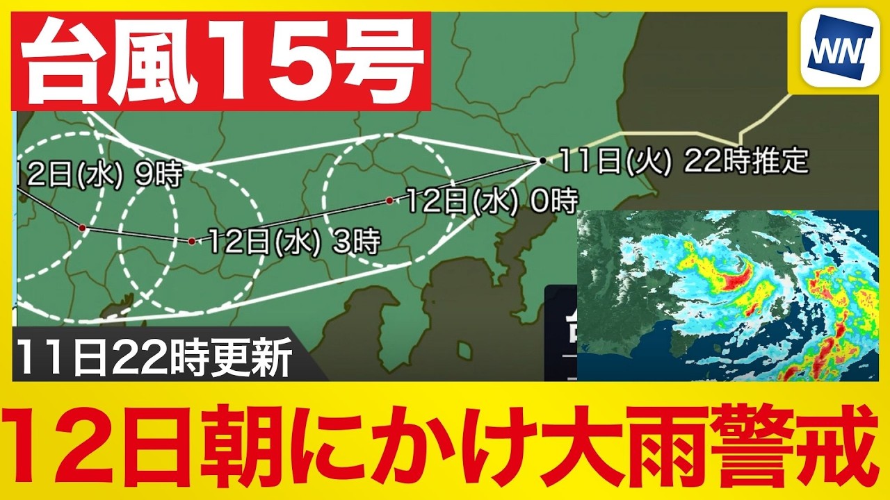
Typhoon No. 15, aka Chan-hom, made landfall in southern Ibaraki Prefecture on 11 August. It was moving across southern Kanto late in the evening, bringing heavy rain and strong winds to Tokyo and surrounding areas. At 10 pm, the typhoon was estimated to be near Kashiwa in Chiba Prefecture. Strong winds were being recorded around the storm, while well-developed rain clouds near and south of its centre brought heavy rainfall to parts of the Tokyo metropolitan area.
One location recorded 28.5 millimetres of rain in an hour as of 10.20 pm, with heavy rain continuing around central Tokyo. Conditions were expected to remain unstable even after the rain clouds over the capital moved away. Forecasts indicated that another band of rain over the Pacific east of Kanto could move inland between midnight and 1 am on 12 August, approaching from the direction of Chiba and Chōshi.
Typhoon No. 16 ("Peilou") is already on its way, but will likely not make landfall.
Typhoon No. 15, aka Chan-hom, made landfall in southern Ibaraki Prefecture on 11 August. It was moving across southern Kanto late in the evening, bringing heavy rain and strong winds to Tokyo and surrounding areas. At 10 pm, the typhoon was estimated to be near Kashiwa in Chiba Prefecture. Strong winds were being recorded around the storm, while well-developed rain clouds near and south of its centre brought heavy rainfall to parts of the Tokyo metropolitan area.
One location recorded 28.5 millimetres of rain in an hour as of 10.20 pm, with heavy rain continuing around central Tokyo. Conditions were expected to remain unstable even after the rain clouds over the capital moved away. Forecasts indicated that another band of rain over the Pacific east of Kanto could move inland between midnight and 1 am on 12 August, approaching from the direction of Chiba and Chōshi.
Rain is expected to intensify again across a wide area of southern Kanto through the early morning of 12 August, with thunderstorms, graupel and hail possible in some locations. The centre of Typhoon No. 15 is forecast to move eastward gradually after midnight, but moist air is expected to continue flowing into eastern Japan even after the storm itself moves away. Forecasters said the unusual track of the typhoon, which has been moving from east to west, could allow humid air to persist behind the system. Typhoons that move from west to east are often followed by drier air and improving weather, but in this case rainfall could continue after the centre has passed. Accumulated rainfall over the following 48 hours is expected to increase particularly along the Pacific side of Tohoku and in the Kanto region, raising the risk of further heavy rain.
Typhoon No. 15 Makes Landfall in Ibaraki and Crosses Kanto
Typhoon No. 15 (Chan-hom) made landfall in southern Ibaraki Prefecture on August 11 and was crossing southern Kanto late in the evening, bringing intense rain and strong winds to Tokyo and surrounding areas while forecasters warned that another band of rain could sweep in from the Pacific after...
newsonjapan.com
Typhoon No. 16 ("Peilou") is already on its way, but will likely not make landfall.


